 |
| Tunnel of Aspen trees early in the hike |
I wanted to get Josh out into the mountains so he could see the changing aspen trees for himself, rather than through my pictures; so I planned a great hike for us, one I had been "saving" since I knew it would be really cool in the fall.
Raspberry Mountain in Pikes National Forest stands 10,605 ft above sea level, a rocky summit that is dwarfed by nearby Pikes Peak. But the views from the top are by far my favorite views on top of any mountain I have climbed so far, including numerous 14ers. There is something really cool about climbing a 'smaller' mountain, you get better views of the scenery below (since you are closer to it) and amazing views of the larger mountains and ranges,; especially with the fall colors giving dimension to the long range views. This is a must hike at any time of the year, but fall just might be the best time of year on Raspberry Mountain.
Getting there: From the town of Divide, Colorado, which is about 30 minutes northwest of Colorado Springs; drive South on highway 67 toward Mueller State Park, 4.2 miles. Go past the State Park for about 200 yards around a curve and turn left onto Teller County Road 62; there is a sign for The Crags Campground. Road 62 is the very next drive past Mueller State Park on the opposite side of the road. Teller CR road 62 is dirt, and the road immediately crosses a creek with a small bridge. You don't want to pass the road because it's difficult to turn around and go back.
Continue on dirt road 62 for just over 1.1 miles and you will reach the small trailhead. It is just before a very sharp hairpin curve to the right; you will see a gate and you can park in front of the gate or on the side of the road. The trail starts here, you will probably see other vehicles here on the weekend.
 |
| The only view of peak (in center)from trail |
Specs: There are no restrooms or maps; just a wide trail that starts in a meadow. The trail to the peak and back is approximately 5-5.5 miles round trip and took us about 3.5 hours to complete, but we spent 40 minutes on the summit. The trail is a two track for much of the hike; however since there are no maps and this is national forest land, there are several other trails that intersect the Raspberry Mountain peak trail. We did make it to the top pretty easily following the trail that is the widest and most obviously; not taking any of the smaller foot trails. Three other pointers I have for this trail are:
1. do not continue down the trail that has numerous power lines and goes sharply downhill; this is the wrong trail. We had no problem skipping this on the way up, but on our way down we nearly took it, notice the power lines visible all the way down the hill, and don't take it.
2. when you reach an intersection with three trails, take the trail to the left (most obviously used) and continue downhill, shortly after this point you will see the rocky Raspberry Peak through the trees and your final destination, the top!
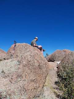
3. The final portion of the hike continues steeply up the bouldery mountainside; you will circle around the peak to the left avoiding the biggest boulders and summit it from the back of the peak; this is the easiest route to the top. The trail gets a little sparse in this area due to rocks, but we found it pretty easily.
The Journey: Sometimes I have a lot to say about a hike, but other times the brilliant photography and scenery can say the most. Here is my photo essay of hiking Raspberry Peak.
The trail starts in a meadow surrounded by aspen trees, in a valley, in Pikes Peak National Forest.
***
The tunnel of Aspen trees. I love this!
***
Above, the trees part often for views of the surrounding mountains especially Pikes Peak.
***
Above; more aspen trees, more pikes peak, Colorado blue sky. Need I say more?
***
Here the trail comes to an intersection with 3 choices, take the path to the left and continue downhill. About 5-10 minutes after this point, you will see Raspberry Peak through the trees if you are observant enough.
***
From here, climb through the boulders (see the carn in the photo front left) and head around to the backside (from this point) of the mountain. Its a much easier climb to the summit. It is near a tree, and a little hard to see, but the trail does take you there.
***
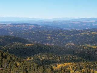
Above, you are greeted with this view when you reach the top! Wow! Catamount Reservoir, Pikes Peak to the east and south
***
Above, views to the northwest and town of Divide.
***
Above, lots of chipmunks on the summit ~ they come right up to you, probably because people feed them (keep the wild, wild, don't feed animals!). If you have dogs that like to chase critters, you might want to leash them on the top, they could actually catch one up here, or tumble off the edge chasing one.
***
Belle is trying her best to catch a chipmunk (don't worry, she is tied up), I love this photo as one is just above her, she stalks a different chipmunk
***
Above, more views, views, views!
***
Catamount Reservoir
***
Eating some lunch on the top :) best views ever!
***
Fall colors as far as the eyes can see
***
Town of Divide below
***
Had to get one cute couple shot on the top before starting to descend.
***
Josh on the bouldery summit while I snap photos from below.
***
Heading down the mountain now. One more shot of the views before we descend into the trees.
***
Nearly back to the car, just walking through the beautiful aspen forest first.
***
End of the hike, still a few cars hiking here.
View Larger Map


Looks like a beautiful hike. I'll have to put it on my long list of hikes that I need to do. By the way, Great Site!
ReplyDeleteThanks Mike! The hike was beautiful, it was worth the 2 hour drive to get there.
ReplyDeleteThinking about trying this hike this upcoming monday hope the fall colors are still in full swing!
ReplyDeleteYay! I'd love to hear how you like it?!
ReplyDeleteIt was great, just past the peak on the aspens but still gorgeous!
ReplyDeleteAwesome! It was a great day to get out there too, probably hot? We are hoping to go camping this weekend after I get done vending at the Farmers Marker for another peek at the aspen trees :)
ReplyDeleteHi Jennifer! We just moved to Woodland Park and I stumbled upon your blog today. I think it's really cool how you have documented your hikes and I am going to definitely use these to plan my hikes. Who knows.....maybe I will start a blog of my own :):)
ReplyDeleteThats great, thanks for reading! I love Woodland Park and there are so many awesome trails with Pikes Peak so close, you will have so much fun exploring!
ReplyDelete