

The Incline is a favorite trail for fitness buffs who frequent the trail as part of an exercise regimen, some people will even run up the trail and back down it as well. Most people however, take the 4 mile Barr trail down the mountain instead. The entire trail provides amazing views of the foothills and as far into the distance as the eye can see and as weather permits.
Getting there: From Manitou Springs, take Ruxton Avenue (off of Manitou Avenue) west toward the mountains at the (left) traffic circle and head up the mountain toward the Barr Trail. Parking is very limited in this area and is a very sensitive issue. The actual incline begins close to the Cog Railway parking lot. Do not park in the Cog Railway parking area. Park in the Barr Trail lot ($5 fee) or park farther downhill along Ruxton Avenue. Some park near the center of town and walk entirely up Ruxton Avenue; others ride their bikes to the start of the trail. If you park in the Barr Trail parking lot, there is a side trail that you will see many people heading to, that takes you up to the Incline, but you won't be starting from the very beginning. We parked here because we didn't know any better and continued up the side trail after speaking to some people in the parking lot to The Incline.
Specs: If you park in the Barr trail lot it costs $5 and there is a restroom and water. The parking lot is small and crowded and the drive is on a steep incline. Because it's so busy, cars will wait for someone to leave and then get that person's spot; so if there is a line when you make it to the parking lot, this is why. The $5 fee is good for 24 hours, so give yours to the next person in line when you leave!
The Hike: This trail is steep, hot, without much shade and without much privacy to use nature's bathroom; so keep that in mind as you hike. Bring LOTS of water on this trail, more than you'd typically need for this length of hike. Josh and I actually ran out of water, which is not the safest thing for a pregnant lady in her 3rd trimester, fortunately I had drank nearly 3 liters on the way up and that sustained me until we made it back to the car. Josh, however, was worried about me not drinking enough water and got himself a little dehydrated trying to save water for baby and I. The hike is on private land, so if you choose to bring your dog, pick up after them because the animals poop on the side of the trail and it really stinks! There is a "bailout" trail if the Incline ends up being too difficult for some reason, you can see it on the left side of the trail, before the first false peak, when the steps get very rickety and uneven. Keep your eyes peeled for it, because it's not super obvious, but noticeable if you are looking for it. Below is my photo journal of the hike.

Prepare yourself, this is what you are doing! You are walking up 2100 feet of incline in under a mile. Its crazy intense and a great accomplishment when you reach the top.
***

See the full parking lot, the Barr trail starts in the far right of this photo; the Incline trail is unmarked but a wide path that continues up from the left side of the parking lot.
***

Walking up the trail, you can see the steps of The Incline above.
***

We stepped on the trail and faced our challenge; the top that you can see here is a false peak and I knew that fortunately otherwise it would have been a sad realization reaching it.
***

Its getting steeper......this is a section where the railroad ties were very well maintained and consistent. They got much worse as the hike went on.
***

Here the stairs start to get a little more rickety as the hike elevation increases; the steps were very large and with my belly I had to really step up hard and keep my momentum forward.
***

Looking back at the views of the city and beyond. Anytime you need to take a breather, there is no shortage of scenery to take in.
***

Nearly to the top of the FALSE peak, this took us about 1 hour and 20 minutes to reach the top of the false peak. And another 50 minutes to make it to the very top. Once you reach the false peak, you have made it through the worst of it and you are about 2/3 of the way done. I was trying to keep my heartrate under 140BPM on the hike, so we were probably the slowest people on the mountain. I don't always follow this rule, but it was easy to get out of breathe on The Incline and this kept me in check.
***

Getting up and over the false peak, finally! You can't even see the trail you just hiked up because it's so steep.
***

And now you see the finish line; the next peak. It's still pretty far away, but I thought this section was easier than the first section.
***

Views looking back down, I kept thinking 'maybe we can see all the way to Kansas,' I don't know if that's possible or not, but it seemed like we had views forever!
***

Almost there! I can see the finish, just a little more...
***

Just a few more steps to go; then if you go to the left, you can take the 4 mile Barr trail back down to the Barr Parking lot. This took another 1.5 hours, making quite a long day of hiking. But I felt pretty happy and accomplished that I did The Incline in my third trimester of pregnancy.
***
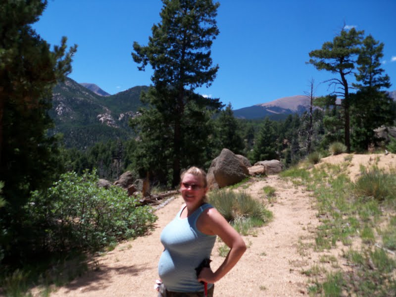
Here I am! All belly, still hiking and feeling great in trimester 3!
***

On the way down along the Barr Trail you are greeted with views of the Cameron Cone peak in the distance, and some short views of Pikes Peak.
***

Taken FROM the Barr trail, this is where you can shortcut OFF the Incline if you need to quit. This is a rickety section along the trail and to the left of the steps the Barr trail is in view.
***

Celebrate! Wa hoo! We did it!
***

One pic of us on the tippy top, even looking over the edge at the finish of the trail is steep!
***
The Incline turned out to be one of the toughest hikes that I have ever done, it was very difficult, but I also had a hard time keeping my speed slow and focusing on what my body was telling me to do. I drank tons of water and didn't use nature's restroom very much, so dehydration was a concern on this trail. It was 90 degrees when we started, fortunately there was a breeze that day. Overall, I'd love to hike this one again! Any hike in Colorado Springs is amazing, I have never found one that I didn't like!
Have you hiked The Incline? Post your comments here and click if you'd like to be updated about future posts!

My brother is making us (from DC) do the incline as our bachelor party the morning of his wedding. Uhhhh, I think we may kill him the night before his wedding...
ReplyDeleteHaha, good luck! What kind of bachelor party is that? I hope there are some beers afterward...
ReplyDeleteThis comment has been removed by a blog administrator.
ReplyDelete